🌾 How disaster reshaped Zeeland's land
The North Sea flood of 1953 left deep scars, but it also sparked a wave of international collaboration. Zeeland’s recovery set off a ripple effect that reached far beyond the Netherlands.

The sea didn’t just take lives in 1953 — it changed the land. Salt crept into the soil. Farms failed. Roads and villages disappeared beneath the water. And when the tide finally withdrew, the Netherlands faced a painful question: how do we rebuild?
This issue revisits that turning point. A story of sorrow, yes — but also of solidarity and ripple effects. Zeeland’s recovery became more than local repair. It shaped new institutions, sparked international collaboration, and left a legacy that still travels far beyond our shores. Let’s begin!
In this week’s issue 📨
- What salt does to the land after a flood
- How Kellogg’s cereal sparked global knowledge-sharing
- A first look at a forgotten archive on land and water
Was this email forwarded to you? Subscribe here
What the flood left behind
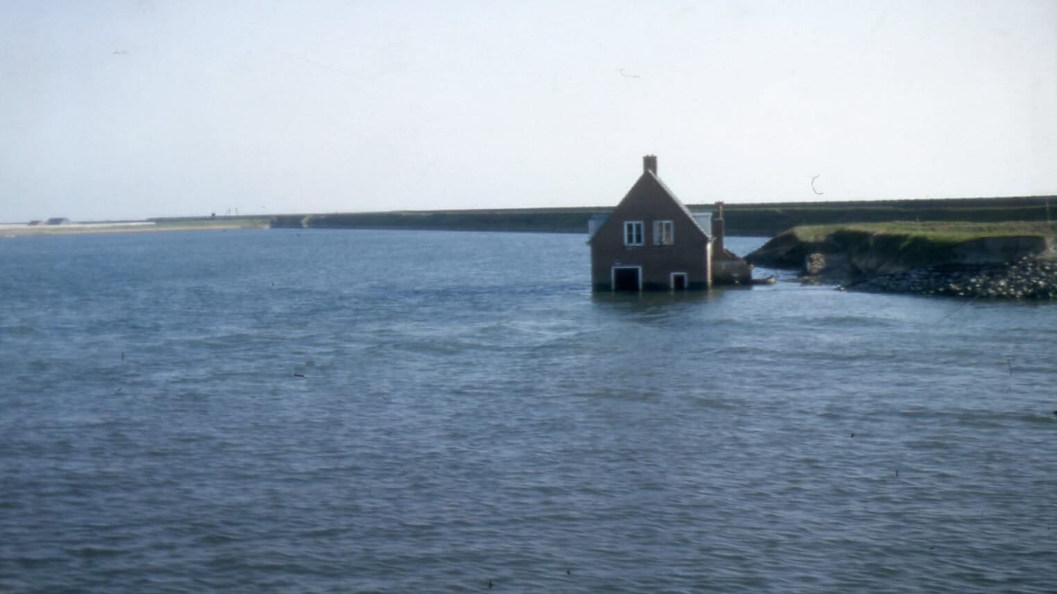
The big North Sea Flood of 1953 hit Schouwen-Duiveland hard. Large parts of the island were underwater, and only a few villages stayed dry. The strong current pushed entire houses away. It was one of the worst disasters in Dutch history, changing the province of Zeeland forever.
More than 200,000 hectares of land were flooded — most of it farmland. When the water finally went down, it left something behind that was hard to see but caused great damage: salt. Salty soil disturbs how plants grow. It pulls water out of the crop, making the plant feel as if there’s a drought. Fields that once grew potatoes and wheat became useless.
Recovery came faster than expected. The Netherlands already had years of experience with drainage and land reclamation. And they were right to trust that knowledge. Just a year later, farmers on Schouwen-Duiveland were back in the fields. Photos by Leendert de Jonge show how straight ditches, cover crops, and careful soil work helped restore the land faster than many had imagined.
Still, the damage led to something bigger. The Dutch government used the crisis to redesign the land. Through a process called ruilverkaveling — land consolidation — Zeeland was reshaped. Small, irregular fields were merged into larger ones. Winding ditches were turned into straight canals. Roads were improved. And new farms were built to better protect against future floods.
These changes helped farming become more efficient. But they also came at a cost. Many small farmers had to give up their land or move away — some even left for countries like New Zealand, Australia, or Canada. The straight canals drained water quickly but left little space to store it during dry periods or heavy rain — a growing concern today. And while the new layout improved food production, it also changed the natural landscape.
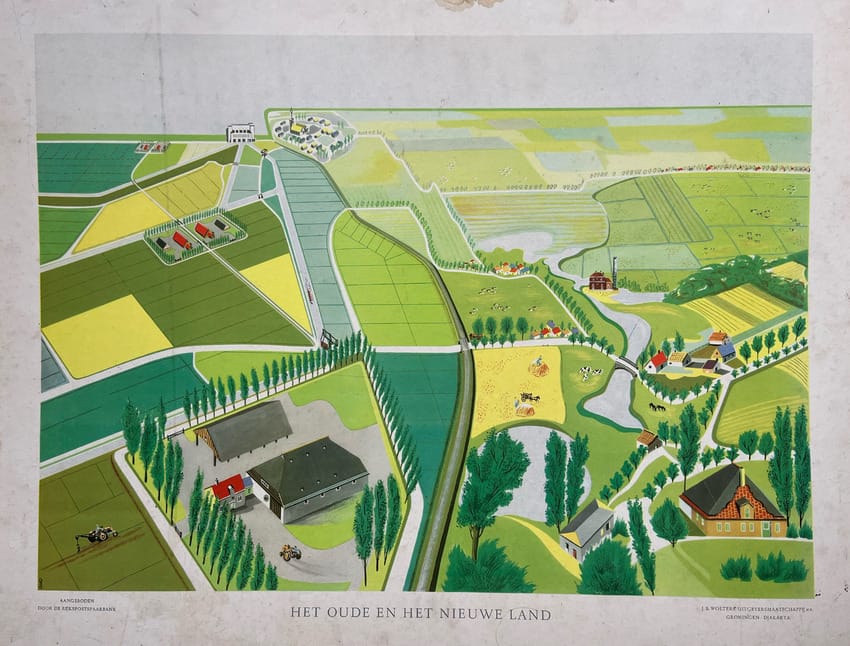
The classroom map above shows a neat division: on the left, the new land — straight, efficient, engineered; on the right, the old landscape — meandering, varied, and shaped by generations of farmers. It presents a story of order and progress. But it doesn’t show the personal loss behind those changes — or how they reshaped both the land and the future, in ways still felt today.
The cereal king and the global classroom
Across the ocean, the W.K. Kellogg Foundation — set up by breakfast cereal maker Will Keith Kellogg — heard about the flood. Although Kellogg had passed away in 1951, his ideas lived on. The Foundation believed in helping people help themselves.
After the disaster, the Foundation pledged 1.3 million guilders to support Dutch farmers. But instead of offering direct aid, the Dutch government proposed something different: using the donation to create an institute that would help not only the Netherlands, but other countries too.
That idea became ILRI — the International Institute for Land Reclamation and Improvement — founded in 1955.
Interesting stories & ideas 📚
- Is Bangladesh losing land to the river? (Photo essay) – Sohan Rahat
- In the Andes, a lesson in listening – Marietta Shimizu-Larenas
- How Almería’s greenhouses are draining its water – Neal Haddaway
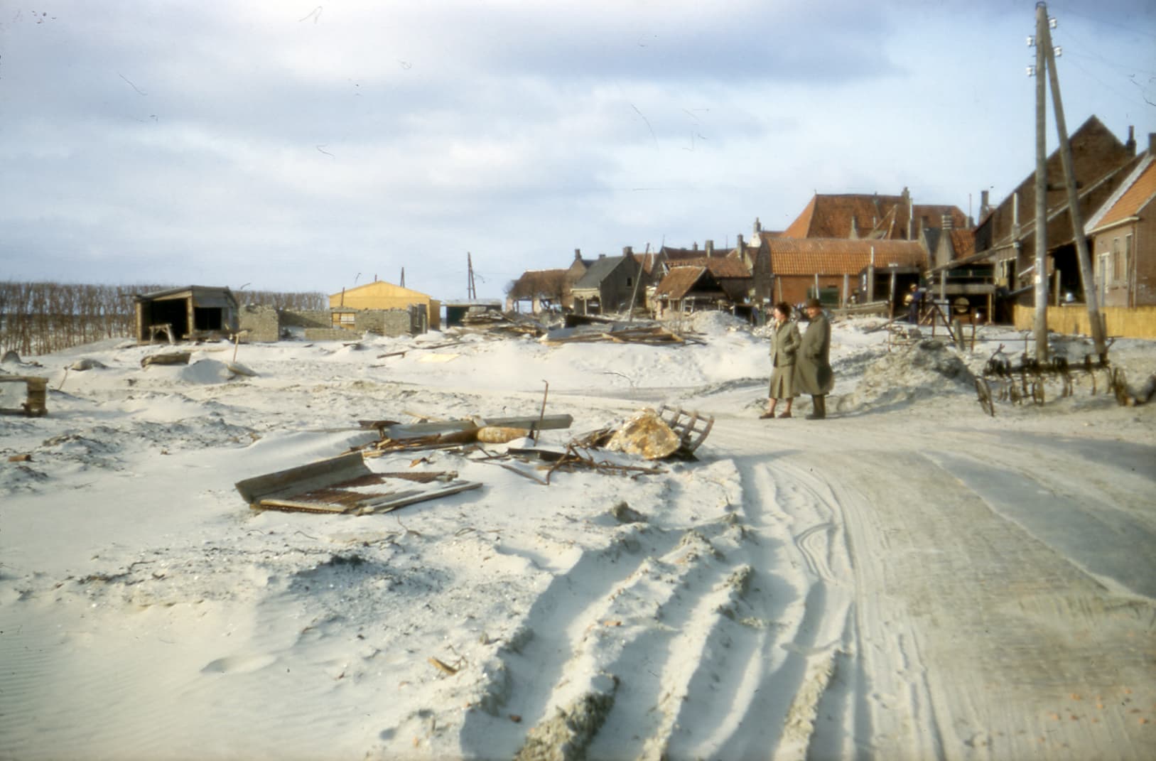
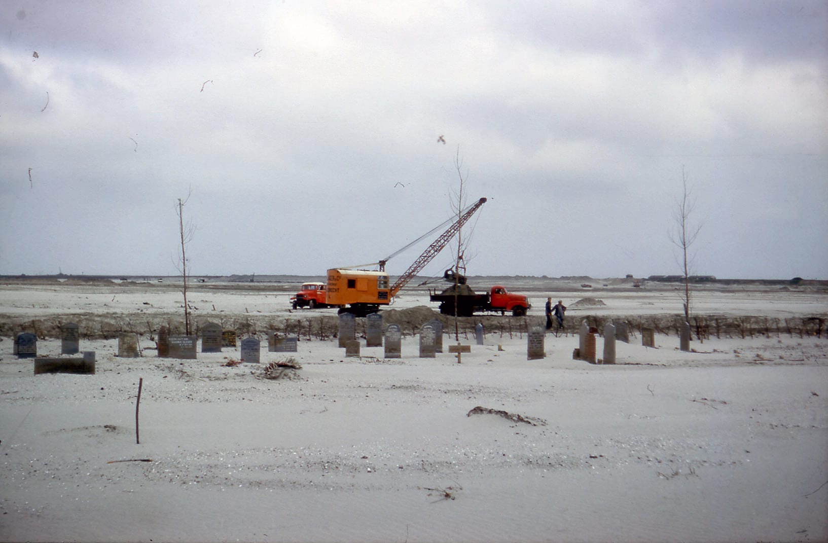

Schouwen-Duiveland in April 1954. Photos by Leendert de Jonge.
From Zeeland to the world
The photos above were taken by Leendert de Jonge, an agricultural professional born in Zeeland and educated in Wageningen. He came to Schouwen-Duiveland just after the flood to study how the land might be rebuilt. His images capture not only recovery, but the beginning of a much larger story.
Many of these photographs, along with ILRI’s founding documents, were recently added to the archive of the Watersnoodmuseum, where we’ve begun exploring their legacy.
That story continued through ILRI. Over the following decades, the institute became a centre of knowledge and exchange. Its mission was clear: to share expertise on land, water, and soil. To train experts. To help prevent future disasters and to stimulate food production in places where it was most needed.
In 2001, ILRI was formally integrated into Alterra, the research institute for green living environments within Wageningen University & Research (WUR). Its mission lives on through international research, education, and collaboration on land and water management.
And, above all, to learn from one another.
Curator’s pick ✍️
Enjoyed this issue? Please share it with a friend or reply to this email. I’d love to hear your thoughts! 👻
Discover the Mekong. Meet the unforgettable people of Vietnam’s Delta. Watch my film here.
Let’s connect! Find me on LinkedIn and Bluesky for quick thoughts. For a deeper dive, visit joepjanssen.com.